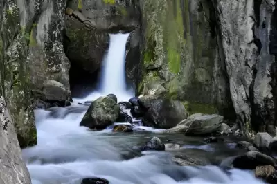
Softaboğan Waterfall is a natural waterfall located in the Osmangazi district of Bursa, at the foothills of Uludağ, strengthened by meltwater in spring, surrounded by pine forests, and a free-to-visit spot.
Hidden within the borders of Bursa's Osmangazi district, on the slopes of Uludağ covered with rich vegetation, Softaboğan Waterfall stands out as one of the city's most beautiful natural escapes. Located in the Dombay Çukuru Valley southeast of the Bakacak area, the waterfall may not have a dramatic high drop, but it captivates visitors with the cool air of the valley, the sound of the stream, and its lush green surroundings. Especially in spring, the melting snows of Uludağ significantly increase the waterfall's flow, making the scenery even more impressive.
To reach the waterfall, the Çobankaya campsite or the Bakacak area are typically used as starting points. The trail, which follows the streambed, offers a very enjoyable route for those seeking a nature walk experience. Picnic areas shaded by pine trees also make the waterfall surroundings suitable for family outings. This natural corner, which reveals itself as you descend from the Bakacak hill overlooking the Bursa plain, is among the indispensable routes for those who want to escape the city noise.
Related discoveries: Places to visit in Bursa, Natural Beauties, Natural beauties of Bursa, Bursa Grand Mosque.
Guide's Note
Best Time to Visit
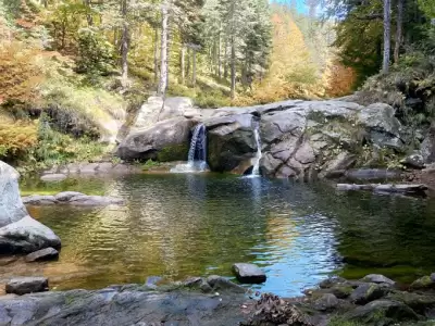
If you want to see Softaboğan Waterfall in its most impressive state, you should choose the period between April and June. During this time, the snowmelt accumulated on the peaks of Uludağ melts, and the waterfall's flow significantly increases; both its sound and appearance become much more striking. The refreshed greenery of the pine forest in May is an added bonus.
Autumn months, especially October and November, hold a special charm for photography enthusiasts as the forest takes on yellow-orange hues. In mid-summer, the waterfall's flow may decrease; however, the cool valley air and shaded picnic areas offer a pleasant option on hot days. In winter, roads can be slippery, so visitors without mountain experience are advised to be careful.
How to Get There
The most common way to reach the waterfall is by private car. It is possible to drive from Bursa city center towards Uludağ up to the Çobankaya campsite. From there, walk approximately 500 meters on the asphalt road towards Bakacak to reach the trail entrance.
For those preferring public transport, minibuses on the Tophane line from Bursa city center offer an option; however, be prepared to walk or find additional transport for the last few kilometers. An alternative way to reach the waterfall is to descend along the streambed; this route is more adventurous but requires appropriate footwear and caution.
Hiking Route and Trail Information
The most popular route is the Sarıalan–Çobankaya–Softaboğan Waterfall trail. According to Wikiloc data, this approximately 10 km long trail, with an elevation gain of 297 meters, is rated as moderate-to-difficult in terms of technical difficulty. The maximum altitude reaches 1,745 meters.
Those who prefer the shorter route starting from the Bakacak area will encounter the unfolding views of the Dombay Çukuru Valley as they descend. The route descending along the streambed is shorter but requires caution due to the rocky terrain. Sturdy hiking shoes are essential on both routes; visitors wearing sports shoes are known to struggle, especially on wet surfaces.
Photo Spots
There are several different photographic angles around the waterfall. The point where the waterfall is framed from the front as you approach from the streambed is ideal for the most classic shot. In the early morning, the light filtering through the forest creates a dramatic atmosphere among the pine trunks.
When you ascend to the Bakacak area, wide-angle panoramic shots encompassing the entire Bursa plain are possible. The play of light over the plain during sunset hours is particularly impressive. In spring, the water mist forming on the rocks directly in front of the waterfall also offers a great opportunity for long-exposure photographs.
What to Eat Nearby
There are no regular dining options immediately near the waterfall area. It is more practical to use the facilities around the Çobankaya campsite or restaurants in Bursa city center before your visit. The area around the waterfall is quite suitable for picnicking; the shaded areas under the pine trees are conducive to spreading a picnic blanket.
On the way back to Bursa, village breakfast places and barbecue restaurants along the Uludağ road are good options. The region is also advantageously located close to the city center for tasting Bursa's famous delicacies such as İskender kebab and chestnut candy.
Things to Consider Before Visiting
The trail to the waterfall follows natural terrain; therefore, sturdy hiking shoes are mandatory. The risk of slipping on wet rocks should not be overlooked. If descending along the streambed, waterproof boots or sandals may be preferred.
Mobile signal can be weak in the area; it is useful to download the route to your phone or GPS device beforehand. Carrying enough water and snacks is also important as there are no markets nearby. It is crucial to not leave trash and not light fires to protect the natural area. It should be remembered that roads can be icy in winter and early spring.
FAQ
Updated: